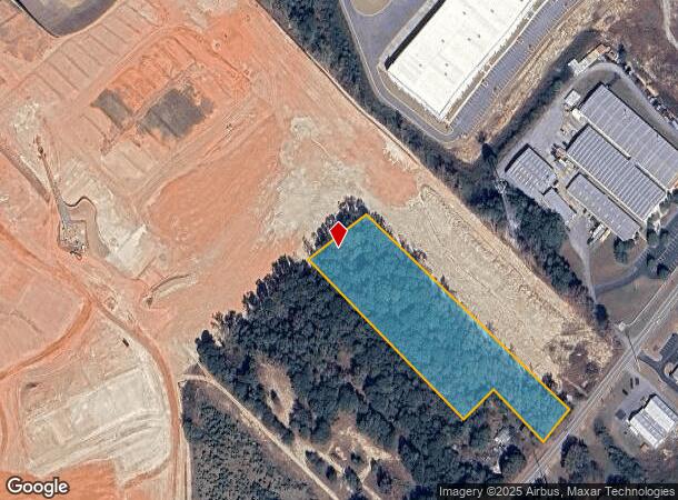
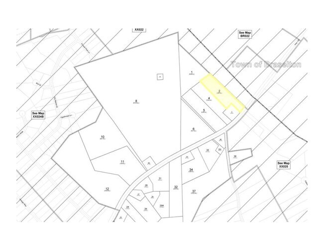
Property Record
1129 Highway 124, Hoschton, GA 30548

NEARBY LISTINGS FOR SALE OR LEASE
Property Detail
1129 Highway 124
Atlanta-Sandy Springs-Roswell, GA
Villas At Winder Phase Ii
XX024-002
TRACT 3
Residentialacreage
Barrow
X
Georgia
13013C0050D
res
2024
3.80 AC
2024
Barrow County
180103
Atlanta
DEMOGRAPHICS near 1129 Highway 124
1 Mile
3 Mile
5 Mile
2024 Total Population
1,562
25,728
63,586
2029 Population
1,857
29,175
72,248
Pop Growth 2024-2029
+ 18.89%
+ 13.40%
+ 13.62%
Average Age
45
39
39
2024 Total Households
573
8,568
21,114
HH Growth 2024-2029
+ 19.20%
+ 13.35%
+ 13.63%
Median Household Inc
$100,772
$111,584
$102,378
Avg Household Size
2.70
3.00
3.00
2024 Avg HH Vehicles
2.00
2.00
2.00
Median Home Value
$293,902
$369,266
$344,358
Median Year Built
2005
2006
2004
Nearby Places
Map Layers
Map Styles
 Street
 Aerial
- Restaurants
- Banks
- Shops
- Fitness
- Groceries
Nearby Properties
Address
Land Use
TOTAL SIZE
Lot Size
Zoning
Address
Land Use
TOTAL SIZE
Lot Size
Zoning
105,000 SF
104.18 AC
POD
Address
Land Use
TOTAL SIZE
Lot Size
Zoning
979,317 SF
107.36 AC
001
Address
Land Use
TOTAL SIZE
Lot Size
Zoning
381,371 SF
77.30 AC
PUD
Address
Land Use
TOTAL SIZE
Lot Size
Zoning
160,277 SF
53.40 AC
PUD
Address
Land Use
TOTAL SIZE
Lot Size
Zoning
613,440 SF
50 AC
003
Address
Land Use
TOTAL SIZE
Lot Size
Zoning
510,720 SF
48.46 AC
M1
Address
Land Use
TOTAL SIZE
Lot Size
Zoning
114,835 SF
15.29 AC
POD
Address
Land Use
TOTAL SIZE
Lot Size
Zoning
521,290 SF
23.60 AC
MD
Address
Land Use
TOTAL SIZE
Lot Size
Zoning
502,088 SF
36.80 AC
MD
Address
Land Use
TOTAL SIZE
Lot Size
Zoning
422,920 SF
24.70 AC
MD
Address
Land Use
TOTAL SIZE
Lot Size
Zoning
500,500 SF
53.92 AC
MI
Address
Land Use
TOTAL SIZE
Lot Size
Zoning
46,400 SF
3.51 AC
G-C
Address
Land Use
TOTAL SIZE
Lot Size
Zoning
805,954 SF
52.41 AC
003
Address
Land Use
TOTAL SIZE
Lot Size
Zoning
547,250 SF
47.51 AC
M1
Address
Land Use
TOTAL SIZE
Lot Size
Zoning
554,285 SF
70.18 AC
Address
Land Use
TOTAL SIZE
Lot Size
Zoning
44,824 SF
3.22 AC
G-C
Address
Land Use
TOTAL SIZE
Lot Size
Zoning
42,053 SF
40.90 AC
PUD
Address
Land Use
TOTAL SIZE
Lot Size
Zoning
24,486 SF
3.85 AC
G-C
Address
Land Use
TOTAL SIZE
Lot Size
Zoning
222,000 SF
20.59 AC
003
Address
Land Use
TOTAL SIZE
Lot Size
Zoning
240,946 SF
21.51 AC
004
Address
Land Use
TOTAL SIZE
Lot Size
Zoning
1,280 SF
24.21 AC
PCD
Address
Land Use
TOTAL SIZE
Lot Size
Zoning
42,848 SF
4.55 AC
G-C
Address
Land Use
TOTAL SIZE
Lot Size
Zoning
76,566 SF
10.30 AC
PUD
Address
Land Use
TOTAL SIZE
Lot Size
Zoning
24,290 SF
6.15 AC
PUD
Address
Land Use
TOTAL SIZE
Lot Size
Zoning
191.82 AC
PUD
Address
Land Use
TOTAL SIZE
Lot Size
Zoning
1,412 SF
43 AC
OI
Address
Land Use
TOTAL SIZE
Lot Size
Zoning
76,792 SF
19.31 AC
003
Address
Land Use
TOTAL SIZE
Lot Size
Zoning
29,212 SF
2.64 AC
N-C
Address
Land Use
TOTAL SIZE
Lot Size
Zoning
8,752 SF
11.40 AC
OI
Address
Land Use
TOTAL SIZE
Lot Size
Zoning
51,710 SF
2.20 AC
GC
The World's #1 Commercial Real Estate Marketplace
Connect with us
© 2025 CoStar Group
The information above has been obtained from sources believed reliable. While we do not doubt its accuracy we have not verified it and make no guarantee, warranty or representation about it. It is your responsibility to independently confirm its accuracy and completeness. Any projections, opinions, assumptions, or estimates used are for example only and do not represent the current or future performance of the property. The value of this transaction to you depends on tax and other factors which should be evaluated by your tax, financial, and legal advisors. You and your advisors should conduct a careful, independent investigation of the property to determine to your satisfaction the suitability of the property for your needs.